WEAN Comments on Oak Harbor DEIS


Use the left and right arrows above to view the 9-slide carousel. Hover to pause.
October 29, 2026
Stacie Pratschner, Community Development Director and SEPA Responsible Official
Rajesh "Cac" Kamak, Principal Planner
City of Oak Harbor
Department of Community Development
865 SE Barrington Drive
Oak Harbor, WA 98277
Submitted by email to Oakharbor2045@oakharbor.org
Re: Comments on the Draft Environmental Impact Statement for the Oak Harbor 2025–2045 Comprehensive Plan Update
Dear Ms. Pratschner, Mr. Kamak, members of the Planning Commission, Mayor, and members of the City Council:
The Whidbey Environmental Action Network (WEAN) submits these comments on the Draft Environmental Impact Statement (DEIS) for the Oak Harbor 2045 Comprehensive Plan Update. WEAN supports the Oak Harbor Garry Oak Society's Proposed Alternative 4. It meets the City's housing goals while protecting habitat, keeping affordable homes near downtown, limiting harmful noise exposure, and avoiding new traffic conflicts on SR 20. We incorporate by reference our scoping comments from March 23, 2026, and ask that the Final EIS (FEIS) respond to each numbered request below, as WAC 197-11-560 requires.
We would like to first begin by acknowledging the environmental and social strengths of the DEIS. We appreciate the City's commitment to affordable housing for multiple income levels and its plans for supportive housing, the new climate and resiliency element, the update of critical area regulations to Best Available Science, and reduced parking requirements. Our comments intend to assist the City reach these goals while protecting the habitat, neighborhoods, and public infrastructure that equitable and sustainable growth depends on.
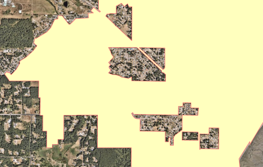
We also appreciate the ongoing work between the City and Island County on the unincorporated neighborhoods surrounded by the city (the "doughnut hole" neighborhoods). We are eager to see that partnership produce and implement a plan for annexing and serving these neighborhoods during this planning cycle. Our scoping letter noted the RCW 82.14.415 annexation sales tax credit, available until July 1, 2028, as one tool that may assist these endeavors.
Whidbey Environmental Action Network
PO Box 293, Langley, WA 98260
www.whidbeyenvironment.org
1. Support for Proposed Alternative 4: Affordable housing where people can walk downtown
WEAN supports the City’s goal of creating affordable housing but believes the newly annexed areas at the city’s southern edge are the wrong place for it. Alternative 3 “creates more affordable housing options within recently annexed areas” (DEIS, p. 31) on land that sits at the city’s periphery, far from downtown businesses, services, transit, and jobs. For lower-income households, the car ownership and travel costs that peripheral housing demands can be a significant barrier to accessing jobs and services. Concentrating affordable housing where residents bear these added costs and have the least access to amenities runs counter to environmental justice principles. Under those principles, the burdens and benefits of growth should be distributed equitably, not loaded onto the households least able to absorb them. The Growth Management Act now directs comprehensive plans to “advance environmental justice” (RCW 36.70A.020(14)), and the DEIS itself relies on the state’s environmental justice definitions to identify overburdened communities (RCW 70A.02.010).
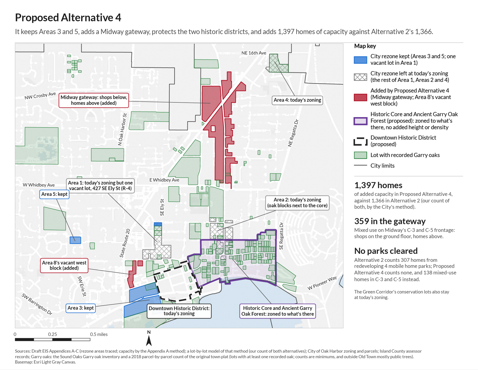
The Oak Harbor Garry Oak Society's proposed Alternative 4 (Figure 1) places increased housing capacity where it better serves residents. Its mixed-use gateway along NE Midway Boulevard puts homes above ground-floor shops, within walking distance of downtown, transit, groceries, and medical offices. A combination of residential and employment density, mixed land uses, and proximity to destinations and transit is associated with reduced vehicle travel (Ewing & Cervero, 2010). Housing located walkable distances from downtown lowers household costs, traffic, and emissions with positive implications for both Oak Harbor residents and the environment.
The gateway’s northern end also connects directly via Goldie Road to the Charles Porter Avenue main gate at Ault Field. NAS Whidbey personnel could live close enough to commute by transit rather than car, which reduces base-related sprawl into the county and the city’s fringes. These transit benefits would extend to every gateway resident, regardless of employer. The City is redesigning Midway (City of Oak Harbor, n.d.), and the draft plan already calls for flexible overlay zoning. It also surfaces the idea for a roundabout at the intersection of NE Midway Boulevard and Goldie Road. Together, these planned investments make the Midway corridor a natural place to concentrate new housing, aligning the City’s infrastructure plans with a growth pattern that serves residents and reduces car dependence.
Where new housing is located matters as much as how much housing is planned. The Growth Management Act directs that urban growth be “located first in areas already characterized by urban growth with adequate existing public facilities” (RCW 36.70A.110(3)), and it requires the housing element to consider housing locations in relation to employment (RCW 36.70A.070(2)(d)(iii)). The City’s own Land Capacity Analysis chose sites for their proximity to “grocery stores, dining, sidewalks, crosswalks, transit lines, department stores, [and] pharmacies” (DEIS Appendix A). However, the DEIS never reports how the alternatives compare on that access. Scored on those same criteria, Proposed Alternative 4 matches or exceeds Alternative 2 on access to transit, groceries, medical offices, schools, and sidewalks (Figure 2). This comparison is essential for assessing whether the plan’s affordable housing is equitable. Affordable units placed where there are no nearby groceries, services, or jobs give lower-income households a home without access to the necessities of daily life. Such capacity should not be weighed equally with capacity in walkable, well-served neighborhoods.
We ask that the FEIS:
Analyze Proposed Alternative 4 using the City's 2026 capacity model, or the Garry Oak Society's lot-by-lot model and GIS data, which the Society has offered to share, including capacity by income band, or explain why it is not reasonable to study (WAC 197-11-440(5)(b)).
2. Planning with an environmental justice lens.
Growth should not come at the expense of Oak Harbor’s most vulnerable residents. Planning through an environmental justice lens guards against both the displacement of affordable housing and exposure to harmful conditions like aircraft noise.
Protect mobile home parks. The DEIS identifies mobile home parks as housing affordable to households earning 50-80% of area median income (DEIS Table 2). Yet the land capacity count treats several parks as land likely to redevelop, without subtracting the homes already there. Counting the replacement of existing affordable homes as new affordable capacity overstates progress and plans for displacing some of the city's most vulnerable residents. The mobile home parks should keep their current zoning, and their aging infrastructure is a reason to invest in them, not replace them.
Account for aircraft noise in every alternative. The Navy’s AICUZ 2021 noise contours show that each action alternative would add housing within high-noise zones near Ault Field (Figure 3). Long-term exposure to aircraft noise is associated with cardiovascular disease, sleep disturbance, and impaired learning in children (Basner et al., 2014; Hansell et al., 2013). The Navy’s own analysis reports baseline noise levels of roughly 40 to 80 dBA (Ldn) around NAS Whidbey (DEIS, p. 184). The upper end of that range is far above the World Health Organization’s (WHO) recommended nighttime limit of 40 dB (WHO, 2011), and all of Oak Harbor exceeds that guideline during the day. Under the AICUZ noise classification model, Alternative 3 would place 356 new homes in the 70-75 dB zone, leaving residents highly vulnerable to the negative effects of noise pollution. We acknowledge that proposed Alternative 4 would place 258 units in the 65-70 dB zone (Noise Subdistrict B) at the northern end of the Midway gateway. We therefore ask the City to strengthen its noise and vibration building standards citywide. For new housing within the 65-70 dB zone, we ask the City to require specific mitigation: upgraded window glazing, mechanical cooling so windows can remain closed, and bedrooms placed on the side of buildings facing away from the airfield. We strongly recommend avoiding development in zones with noise levels of 70 dB and higher.
We ask that the FEIS:
- Ensure that no existing mobile home park is designated for redevelopment under the preferred alternative (see Proposed Alternative 4) and remove any housing capacity counted on trailer park land.
- Strengthen noise and vibration building standards citywide and require enhanced mitigation for new housing within the 65–70 dB contour.
- Analyze overburdened communities under each alternative. The DEIS maps where overburdened communities are today, but never asks whether rezones, traffic, noise, or displacement under each alternative would fall disproportionately on them.
3. Protect green space and wildlife habitat.
Make the Garry oak significance finding. Oak woodlands are a WDFW Priority Habitat, and the DEIS names Garry oak ecosystems in its own significance threshold. It also concedes that every alternative will cause oak loss, but it never says whether that threshold is met. Large old trees are keystone structures that support wildlife and cannot be replaced within a short planning window. WEAN supports the Garry Oak Society's request for a Garry Oak Overlay, oak-specific mitigation, and a commitment not to weaken OHMC Chapter 20.16.
Survey Area 6 before any rezone. Alternative 3 would rezone about 75 acres of recently annexed land to commercial and high-density residential. This land is largely forested and has not been surveyed for oaks or other ecologically valuable resources. Rezoning it for dense development would break up contiguous forest at the city's edge. A synthesis of the world's longest-running fragmentation experiments found that habitat fragmentation reduces biodiversity by 13 to 75 percent and impairs ecosystem functions, with losses that intensify over time (Haddad et al., 2015). Furthermore, new impervious surface and roads introduced into the forested area will degrade receiving waters (Booth & Jackson, 1997) and introduce tire-derived 6PPD-quinone from road runoff, which is acutely lethal to coho salmon (Tian et al., 2021). These losses are not only ecological. Intact forest provides stormwater retention, cooling, and close-to-home access to nature for Oak Harbor residents, which is associated with better physical and mental health (Twohig-Bennett & Jones, 2018).
Protect tree canopy. Oak Harbor's canopy is about 23% and projected to decline (Oak Harbor Garry Oak Society, 2026, Comment 3) with implications for ecosystem and human health. Increasing urban tree cover lowers city temperatures and is estimated to prevent a substantial share of heat-related deaths (Iungman et al., 2023).
Establish greenways and habitat corridors. WEAN supports the Garry Oak Society’s proposed Green Corridor, which links oak savanna, parks, and wetlands, mostly on existing public land (Figure 4; Oak Harbor Garry Oak Society, 2026, Comment 11). Corridors that connect habitat help plants and animals move across developed landscapes and support greater biodiversity than isolated patches (Gilbert-Norton et al., 2010). Because corridors can serve different purposes, the City could designate them according to defined tiers. Green corridors are not intended to prohibit development but to encourage developers and homeowners to incorporate sustainable building and design elements, such as green roofs, native plantings that support biodiversity, and conserved open space.
The draft Comprehensive Plan identifies a Waterloo Marsh–Swantown Lake open space link (Open Space policy n), which is also described in the City’s 2019 Parks, Recreation, and Open Space Plan (City of Oak Harbor, 2019), but the DEIS neither maps it nor identifies the lands it includes. A wildlife corridor from Waterloo Marsh to Swantown Lake would protect an important Type F (fish-bearing) stream (DEIS, p. 157) and associated wetland and riparian resources, and would incorporate the park and easement lands surrounding them so that conservation advances alongside development (Figure 5). Similarly, a Crosby Wildlife Corridor (Figure 6) would connect the city to the western edge of the island, protect additional wetland habitat, and incorporate Freedom Park. The Crosby Corridor could join the Waterloo–Swantown corridor so wildlife can safely travel greater distances. Managing critical areas in these zones is especially important considering much of Oak Harbors future growth is directed to the south and west.
Additional opportunities for wildlife corridors include Maylor Point (Figure 7), which holds Indigenous cultural value, old-growth Garry oaks, and a remnant population of golden paintbrush (Castilleja levisecta). This rare plant is native to glacial outwash prairie, a habitat of local importance in Island County. A Crescent Harbor corridor (Figure 8) established in collaboration with NAS Whidbey would connect the coastline, the Crescent Harbor wetland network, and adjacent Navy open space.
Taken together, this network of corridors (Figure 9) would allow Oak Harbor to conserve its highest-priority ecological areas and keep them connected as the city develops. Identifying these high priority conservation areas now ensures that the habitat and ecosystem services they provide are not lost. The establishment of these wildlife corridors may also planners with guidance on appropriate and reasonable uses of parcels surrounding critical areas. Because many of these corridors extend beyond city limits or onto Navy land, we invite a collaborative, long-term vision with Island County and NAS Whidbey. Adopting any or all of these corridors would support the health and well-being of both Oak Harbor’s residents and its ecosystems.
We ask that the FEIS:
- State whether the Garry oak significance threshold is met under each alternative and apply the mitigation sequence, with avoidance first. WEAN's clear preference is that the preferred alternative avoid removal of Garry oaks and their critical root zones altogether, as Proposed Alternative 4 largely does. Oak-specific minimization and compensatory measures should apply only where avoidance is demonstrably infeasible.
- Defer any Area 6 rezone until a habitat survey is complete.
- Adopt a canopy target with a no-net-loss policy for upzoned areas.
- Map and designate a tiered network of greenways and habitat corridors in coordination with NAS Whidbey Island and Island County where appropriate. Consider native plantings and connectivity-preserving designs for development within them.
4. Assess transportation challenges on SR 20 and the south annexation area
The DEIS identifies improvements but no intersection analysis. WEAN appreciates that the DEIS outlines transportation improvements under each alternative, including planned Midway Boulevard and Swantown Road improvements, expanded pedestrian, bicycle, and transit service, roundabouts at key SR 20 intersections supported by a 2005 WSDOT corridor study, and new non-motorized connections such as a southern link between SR 20 and SW Fort Nugent Avenue (DEIS, pp. 217–219). However, the DEIS describes traffic impacts only in general terms and concedes that “any of the three alternatives may lead to vehicular delay along SR 20 not meeting the vehicular LOS E threshold during the AM and PM peak hours” (DEIS, p. 219). It also reports no peak-hour results at any SR 20 intersection. Without these results, decision-makers cannot compare how the alternatives perform on the island’s main highway or assess whether the proposed improvements are sufficient. Finally, none of the roundabouts proposed for Alternative 3 are near Area 6, where that alternative’s largest rezone would add traffic.
SR 20 capacity is a concurrency requirement. Concurrency rules generally exempt state highways of statewide significance. The exception is island counties whose only connection to the mainland is state highways or ferries, where state highway capacity must be a factor in meeting concurrency (RCW 36.70A.070(6)(a)(iii)(C)). SR 20 is North Whidbey’s only highway link to the mainland. It carries island-wide commuter, freight, and emergency traffic. Oak Harbor must therefore demonstrate that SR 20 can accommodate the traffic each alternative would generate before adopting land use changes that add to it.
Area 6 development adds traffic to a known traffic issue area. In 2026, WSDOT lowered speed limits on SR 20 south of Oak Harbor to 35 mph (mileposts 30.26–30.77) and 30 mph (mileposts 30.77–31.29). WSDOT conducted a speed analysis and concluded that the reductions “will better match current driving speeds, traffic volumes and the design of the road”, confirming the design limits of this segment. Alternative 3’s Area 6 rezone would send new commercial and high-density residential trips onto this segment near Swantown Avenue and Waterloo Road. Furthermore, Waterloo Road itself is narrow, about one vehicle wide for much of its length, making the area poorly suited to increased density.
By contrast, the Midway gateway in Proposed Alternative 4 places housing away from SR 20 on a city street grid already served by transit and within walking distance of daily needs. As aforementioned, because housing near destinations and transit is associated with less driving, this pattern can shorten or replace car trips rather than funneling them onto the highway (Ewing & Cervero, 2010).
We ask that the FEIS:
- Model peak-hour level of service at the SR 20 intersections affected by each alternative, including SR 20 at Swantown Avenue and Waterloo Road, and Proposed Alternative 4's Midway gateway at NE Midway Boulevard/Goldie Road.
- Defer any Area 6 rezone until that analysis is complete and solutions are presented.
5. Ground the Oak Harbor Comprehensive Plan’s growth in funded infrastructure, accurate targets, and adequate access to city parks.
A Capital Facilities Plan must support the added growth. The GMA requires a capital facilities element with at least a six-year financing plan (RCW 36.70A.070(3)), and public facilities must be adequate to serve development when it occurs (RCW 36.70A.020(12)). The DEIS relies on the 2023 Capital Facilities Plan, prepared for the current plan's growth, and pairs neither action alternative with a CFP for the added capacity. Island County cited the same gap in rejecting the City's earlier UGA proposal (see WEAN scoping comments, March 23, 2026). Under the DEIS, Alternative 2 provides capacity for 6,085 units (152% of the allocation) and Alternative 3 for 7,376 units (185% of the allocation; DEIS Table 5). Planning for 52-85% more housing than the allocation without a funded infrastructure plan compounds this deficiency.
Appendix A uses an outdated housing target. The land capacity memos in Appendix A still measure capacity against a 5,533-unit allocation and report a deficit of about 2,800 units. The County reduced the allocation to 3,992 units in December 2025, and the DEIS references 3,992. Appendix A should be updated so the record rests on one consistent target.
Close the neighborhood park deficit where density is added. The City already falls short of its 1.5 acres per 1,000 residents standard for neighborhood parks (DEIS Table 52, Parks section). The DEIS projects that the deficit will grow to about 26 acres under Alternative 2 and 30 acres under Alternative 3 (Tables 54 and 55) but proposes no acquisition. The community-park surplus depends largely on Freedom Park, 75 acres that remain mostly undeveloped. Access to nearby green space is associated with better physical and mental health (Twohig-Bennett & Jones, 2018), and is critical for both human and ecological wellness, especially in the dense neighborhoods that the action alternatives would upzone. Adoption of new wildlife corridors as presented in section 3 could be a valuable first step in addressing this deficit.
Dedicate parkland in newly annexed neighborhoods. By annexing land to the south, the City is creating new residential neighborhoods where nearby green space will be essential to residents’ health and quality of life. Annexation and the development that follows will also reduce existing open space. The plan should offset that loss by dedicating City parkland within or adjacent to the annexed areas to ensure future residents have access to these benefits. Oak Harbor’s unmet neighborhood park standard of 1.5 acres per 1,000 residents and is below the national standard. Nationally, the typical park and recreation agency manages 10 acres of parkland per 1,000 residents (11.2 acres for jurisdictions of 20,000 to 49,999 people; National Recreation and Park Association, 2026). State law allows cities to require developers to dedicate land, or pay fees in lieu, for parks reasonably necessary as a direct result of new development (RCW 82.02.020). The City should use this tool in the annexation area.
Disclose NAS Whidbey assumptions. The DEIS assumes the Navy's workforce will keep growing. As we requested in scoping, the FEIS should disclose that assumption's basis and test a reduced-operations scenario.
We ask that the FEIS:
- Identify a Capital Facilities Plan, or a dated schedule to adopt one, that funds the infrastructure the preferred alternative requires.
- Revise Appendix A to reflect the 3,992-unit allocation.
- Commit to a neighborhood park acquisition plan, with locations prioritized for upzoned areas.
- Require parkland dedication, or fees in lieu, for new residential development in recently annexed areas, and identify park sites there before rezoning.
- Disclose and justify NAS Whidbey population assumptions.
6. Let the public review the preferred alternative.
The DEIS says the preferred alternative will be identified in the Final EIS. If the preferred alternative first appears in the FEIS, the public will see the actual plan only after the comment period has closed.
We ask that the City publish the preferred alternative, with its maps and capacity by income band, and accept public comment on it before the Planning Commission hearing. Please also keep WEAN on the list of parties of record and notify us of the FEIS, the preferred alternative, and all Planning Commission and City Council hearings on the 2045 Comprehensive Plan Update, including the related zoning and development code amendments.
Conclusion
Oak Harbor can readily meet its housing allocation while simultaneously protecting the environment, keeping mobile home park residents in their homes, and placing affordable housing where residents can walk downtown. Because Proposed Alternative 4 demonstrates that these objectives can be achieved together, WEAN respectfully urges the City to evaluate it and to address the points identified above. Many of these issues, including habitat corridors, SR 20 traffic, and aircraft noise, extend beyond city limits, and we encourage continued collaboration among the City, Island County, and NAS Whidbey as the plan moves forward. Thank you for the opportunity to comment. We would be glad to discuss these comments with staff.
Respectfully submitted,
Autumn Maust, Ph.D.
Program Director
Whidbey Environmental Action Network
programs@whidbeyenvironment.org
With Marnie Jackson
Executive Director
Whidbey Environmental Action Network
ed@whidbeyenvironment.org
CC: Island County Board of Commissioners (Melanie Bacon, Jill Johnson, Janet St. Clair); Island County Planning & Community Development (CompPlan@islandcountywa.gov)
References
Basner, M., Babisch, W., Davis, A., Brink, M., Clark, C., Janssen, S., & Stansfeld, S. (2014). Auditory and non-auditory effects of noise on health.
The Lancet, 383(9925), 1325–1332.
Booth, D. B., & Jackson, C. R. (1997). Urbanization of aquatic systems: Degradation thresholds, stormwater detection, and the limits of mitigation.
Journal of the American Water Resources Association, 33(5), 1077–1090.
City of Oak Harbor. (n.d.).
Midway Blvd improvements: Design and permitting. Retrieved October 23, 2026, from
https://www.oakharbor.gov/994/Midway-Blvd-Improvements-Design-and-Perm
City of Oak Harbor. (2019).
Parks, recreation, and open space plan.
https://oakharbor.gov/DocumentCenter/View/480/Parks-Recreation-and-Open-Space-Plan-PDF
Ewing, R., & Cervero, R. (2010). Travel and the built environment: A meta-analysis.
Journal of the American Planning Association, 76(3), 265–294.
Gilbert-Norton, L., Wilson, R., Stevens, J. R., & Beard, K. H. (2010). A meta-analytic review of corridor effectiveness.
Conservation Biology, 24(3), 660–668.
Haddad, N. M., Brudvig, L. A., Clobert, J., Davies, K. F., Gonzalez, A., Holt, R. D., et al. (2015). Habitat fragmentation and its lasting impact on Earth's ecosystems.
Science Advances, 1(2), e1500052.
Hansell, A. L., Blangiardo, M., Fortunato, L., Floud, S., de Hoogh, K., Fecht, D., et al. (2013). Aircraft noise and cardiovascular disease near Heathrow airport in London: Small area study.
BMJ, 347, f5432.
Iungman, T., Cirach, M., Marando, F., Pereira Barboza, E., Khomenko, S., Masselot, P., et al. (2023). Cooling cities through urban green infrastructure: A health impact assessment of European cities.
The Lancet, 401(10376), 577–589.
National Recreation and Park Association. (2026).
2026 NRPA agency performance review.
https://www.nrpa.org/globalassets/research/research-reports/2026-agency-performance-review.pdf
Tian, Z., Zhao, H., Peter, K. T., Gonzalez, M., Wetzel, J., Wu, C., et al. (2021). A ubiquitous tire rubber–derived chemical induces acute mortality in coho salmon.
Science, 371(6525), 185–189.
Twohig-Bennett, C., & Jones, A. (2018). The health benefits of the great outdoors: A systematic review and meta-analysis of greenspace exposure and health outcomes.
Environmental Research, 166, 628–637.
World Health Organization Regional Office for Europe. (2011, December 1).
Noise
[Fact sheet].
https://www.who.int/europe/news-room/fact-sheets/item/noise